


The Route of the Valleys It is a journey through the best preserved natural areas in the Hellin region: Valleys Agramón and Mines, World and crossed by the river Segura and divided by the Sierra de Los Donceles.
In the fertile valleys that form these rivers, we will enjoy strolling through the fruit orchards and vast fields of rice "Bomba", which is considered one of the best rice dishes in the world. Also ascend to the top of the Sierra de Los Donceles, to jump right into one of the wildest and untouched pockets of Mediterranean forest.
Valle de Agramón
Tedelche. Photo: Antonio Callejas Gallar.
Enter the Valley for the deviation from Minateda-Agramón that starts from the N-301, up to the Tolmo. We will continue this county road A-14 until you reach Minateda, small hamlet where the shelters that house the famous cave paintings, dating from the Paleolithic. This is one of the most representative traces Levantine Rock Art.
Shortly later we reached the village of Gallows. To our right we saw flanked by Flathead, and left by the course of Arroyo Tobarra.
El valle opens from here, leaving behind numerous small sites from settlements that once controlled the way to the hamlet of Agramón. We continue our journey and take the road that goes towards Agramón Mines. After crossing the bridge over the Rio Mundo, must be very careful because some 200 meters, in a sharp curve, the beginning is the indicator Hannibal Way, part to our right along a forest track that leads to the piedmont zone that runs parallel to the river valley.
The following prompt us into the mountain itself.
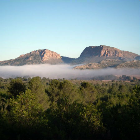
After the climb is advisable to make a first stop on the hill, from where we can see a stunningly beautiful view of the whole valley and volcano Agramón Cancarix. And if we climb a little, from the same point and to the right of way, we can access to the peak of Donceles, highest point of the Sierra.
Valley Mine
Then we began the descent that leads to new valley, crisscrossed by the Segura River. We reached the place of the Prado Piñero, named for the abundance of Aleppo pines and squires, which are those that give their name to this mountain. At the end of this fall we will find a new landscape given the tortuous meandering river Segura, running forming numerous beaches and we amazed by the beauty of its lush vegetation and its deep gorges and canyons.
Continuing along the left bank of the river will find beautiful landscapes among which La La Chamorra and the Maeso Closed. Leaving these gorges, the landscape changes again abruptly and the peculiar geology of the area happens to become the protagonist, resulting volcanic curiosities such as Python or sulphurous formations Salmerón, that led to a major mining for centuries and that will be our next destination: the village of Las Minas, that arrive from the Maeso, leaving it to our left and continue along the path we.
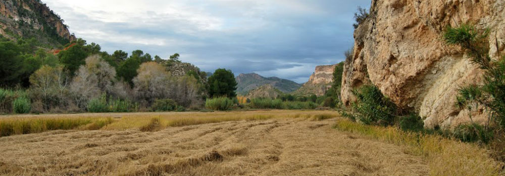
Rice fields in the Chamorra. Photo: Antonio Callejas Gallar.
Town of Mine
The village of Las Minas is located on the left bank of the River Segura, near its confluence with the River World. It received its name because of the birth of sulfur that exists in the area, and apparently it is already exploited in Roman times. The first documentary evidence of these mines is 1569, but it is from the eighteenth century when in full production. In the mid nineteenth century, almost the entire Spanish sulfur, essential for manufacture of the powder, Mine comes from Hellin.
This caused the people to grow significantly. The favorable context of the First World War and the Spanish Civil War contributed to increased production, but depletion of the richest and later competition with French and American sulfur reefs caused its closure in 1960. In 1980 entire village of Las Minas, that was-and still is today- the preserve, was sold for a price of seven and a half million pesetas.
The tour is very interesting and worth a stroll along the nearby, discovering traces of the past. The current configuration has a landscape characterized by huge deposits of slag (Waste material ovens) coming to be real mountains in which only occasionally grow bushy plants. Above them are remains of several sets of cylindrical furnaces, disused mines, old transformers that provided power to propel “malacates” with ascending and descending upon the workers to the mines, remnants of the railway line, etc. At the top we find remains of the buildings facing the public service; from the chapel to prison, through a cinema or a store of provisions.
Canyon Almadenes
Past the houses of the village, There is an area of semirrupestres houses or cave houses where they lived most of the workers. Most of them are painted with azulete which is a natural disinfectant.
We left this hamlet, by a paved track in good condition, along the valley, that leads to the old railway station. To our left we find a way forward, as this is what leads us to “The Canyon Almadenes”. We passed under a tunnel that connects to an old mine shaft. Without abandoning this road pass next to a small power and continue until it ends. From here we continue walking for a few meters to get into the metal walkway that will allow us to enter into the canyon itself. A spectacular view awaits us there, heavily into the roar of the waters of the river Mundo drilled for thousands of years this fantastic landscape of towering limestone walls.

Canyon of Almadenes. Photo: Antonio Callejas Gallar. Collection Antonio Selva.
Riverbank World
We retraced our steps and we return now following the riverbank World. Thus we find “The Board”, it is the place where the world pours in the Segura. Another place of breathtaking beauty, Green paisaje, immense rice fields where the famous rice growing “Bomba”.
Now we return to the Mines and, before reaching, should take the road, to our right, part toward Agramón. About four miles we find a crossing to the right that leads to the Town Cliques. Visit the houses of the same, from where a panoramic marsh of the same name referred.
Y luego return, before reaching the crossing, we turn to our left, into the dam. After the tunnel will enjoy another breathtaking view of the canyon's time to return to Almadenes.Es Agramón, but on the way back the landscape offers us a thousand other excuses to stop and recreate.